Contact
Lenses · one corridor, every protocol

Read the corridor you already captured through any protocol.

A Lens is a named, versioned reading of a corridor. It looks at every panorama for what one program tracks, places each observation where it is visible, and hands your staff a verification list. No re-capture, no new field days, and nothing becomes a finding until a person says so.

Open a Lens in the viewer ↗ Commission a Lens
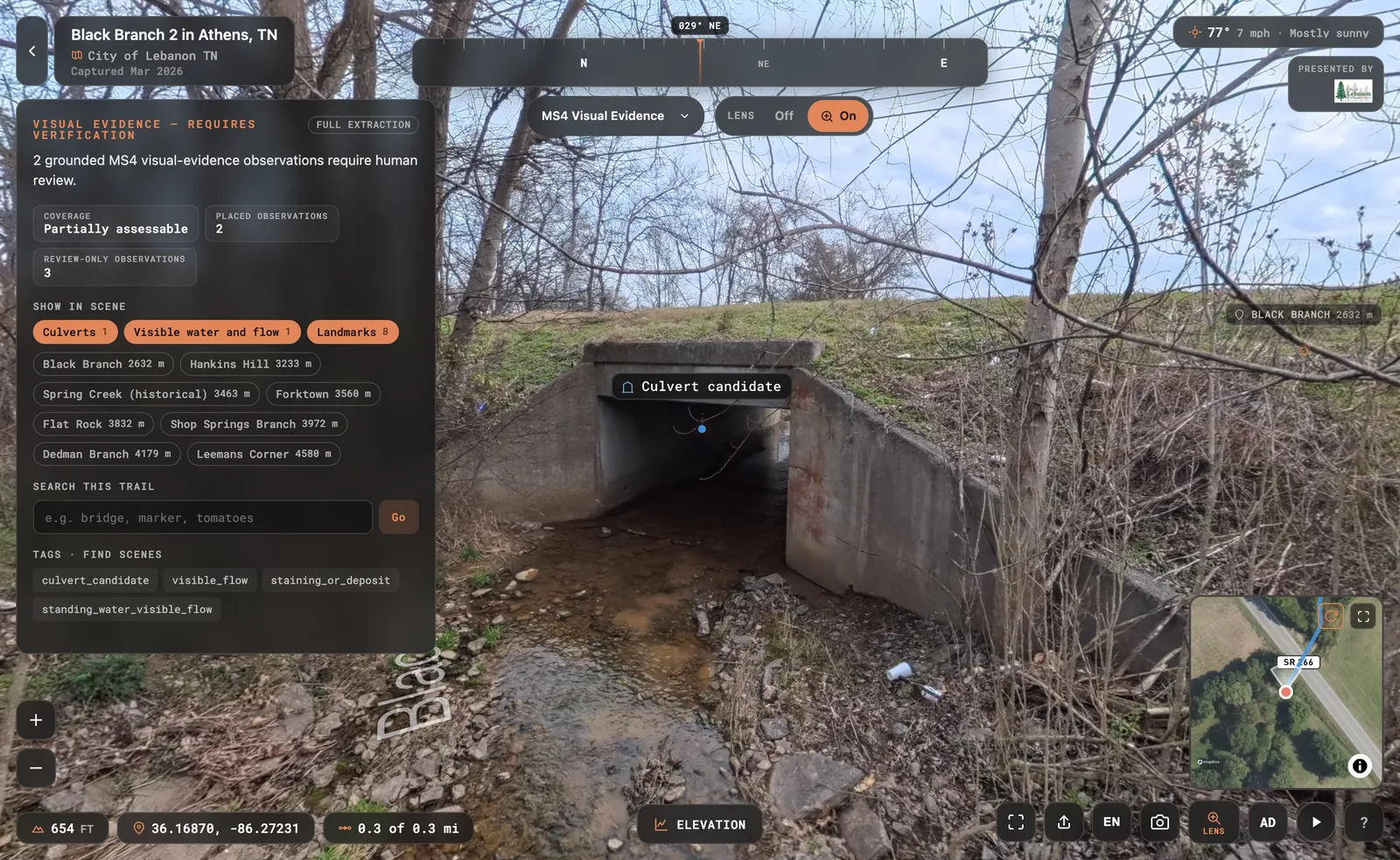
The MS4 Visual Evidence Lens on Black Branch 2: the SR 266 box culvert with the culvert candidate placed on the structure and flow marked in the channel
MS4 Visual Evidence Lens · Black Branch 2, Lebanon TN · scene 52, the SR 266 culvert from the channel 2 placed observations · culvert candidate, visible flow · 3 more for review
Named

One protocol, one vocabulary.

Each Lens carries a fixed set of categories and labels written for the program it serves. Labels never come from free text, so two people reading the same scene see the same words.

Versioned

The read has a history.

Schema and prompt versions travel with every result. Recapture the corridor and the same Lens reads it again, so change is measured against a known baseline, not a memory.

Verified

Evidence, not findings.

A Lens says what is visible and how confident it is. Your staff confirm it in the viewer or the field. It supports GIS, inspection, sampling, and permit records; it does not replace them.

How a Lens is built

Four steps from a protocol to a reviewed corridor.

01

Evidence boundary

We write the rule set with you: what eye-level imagery can show, what it cannot, and what stays with your records. That boundary is the Lens.

02

Sample read

A handful of representative scenes are read first. Your staff review each observation, its placement, and the false positives before anything scales.

03

Corridor read

Every panorama is read against the protocol. Each observation lands in the scene where it is visible, with a confidence and the face it came from.

04

Verification

Observations stay evidence until a person confirms them, in the viewer or in the field. Reviewed results export to your GIS with their coordinates and bearings.

The Lens library

Three Lenses are live in the viewer today. One more is on the bench.

Every link opens a real trail with the Lens switched on. Select any marker to see the observation, its confidence, and the panorama face it came from.

live on every public scene

Scene Intelligence

For Everyone who opens a scene

Landmarks, infrastructure, surfaces, signage, water, and conditions on every panorama, placed where they are visible and searchable across the whole trail.

Open Virginia Capital Trail ↗
live client protocol

RAPG Access-Site Lens

For River managers and access-site programs

Role, surface, safety, use, and naturalness for every access scene, with each observation pinned to the ramp, the bar, or the sign it describes.

Open Polebridge, North Fork Flathead ↗
MS4 Visual Evidence Lens in the viewer
live client protocol

MS4 Visual Evidence Lens

For Stormwater divisions and utilities under an MS4 permit

Stormwater asset candidates (inlets, culverts, outfalls, grates, swales), visible condition signals, and the field task each one needs. Evidence to verify, never a finding.

Open Black Branch 2, the SR 266 culvert ↗ Open Brookside Reservation ↗
in development adapter in progress

NPS Visual Resource Lens

For Park planners documenting scenic quality and visual change

Visual-resource observations along a corridor, read against the NPS visual resource inventory vocabulary, so a scenic baseline can be revisited scene by scene.

Demo link when the first corridor is reviewed.
Built to order

A Lens for any protocol eye-level imagery can inform.

These are the readings we get asked for most. Each starts with the evidence boundary and a sample your staff review, then reads the whole corridor. If your program has a field form, it can probably be a Lens.

Trail conditions & accessibility
Surface type, width cues, obstacles, steps, and grade indicators for ADA and maintenance planning.
Signage & wayfinding
Every visible sign, its legibility, and the scenes where a marker or blaze is missing.
Bank erosion & shoreline
Undercut banks, exposed roots, slumping, and revetment condition along a river or lake edge.
Invasive vegetation
Visible stands of target species where the imagery can support a field check.
Encroachment & boundary
Structures, dumping, fences, and use marks along an easement or a corridor boundary.
Hazard trees & storm damage
Leaning, dead, or fallen trees over the tread, blowdown, and blocked crossings after an event.
Campsite & amenity inventory
Sites, fire rings, kiosks, benches, and access points, located and photographed in context.
What a Lens is not

Not an inventory. A panorama shows what was visible from the path on the day of capture. Anything hidden by vegetation, distance, or a manhole lid is recorded as not assessable, never as absent.

Not a finding. No Lens asserts permit compliance, a discharge, ownership, or water quality. It points a person at the scene and says what to check.

Not a replacement for records. Reviewed observations join your GIS, inspection, sampling, and permit records with their coordinates and bearings. They add a located photograph to each row; they do not overwrite it.

Have a protocol? Have a corridor?

Bring the field form. We will show you what a Lens sees on a handful of your own scenes before you commit to a corridor.

Commission a Lens How a scene is read