Black Branch 2
Scene #4
City of Lebanon TN
36.170057, -86.268409 | 193m
Captured: Mar 4, 2026 11:05 AM
4.5m to prev | 5.5m to next


NPS Visual Resource Inventory Overview
NPS Scenic Quality Assessment
Scenic quality data not available. This may be using an older analysis format.
NPS View Importance Assessment
View importance data not available. This may be using an older analysis format.
NPS Landscape Elements
Landscape elements data not available in site-level format. Check per-face analysis for element data.
NPS Prominent Design Elements
Design elements data not available in site-level format. Check per-face analysis for element data.
Per-Face VRI Analysis
Front Face (NW - 310°)
Right Face (NE - 40°)
Back Face (SE - 130°)
Left Face (SW - 220°)
Up Face
Down Face
Matrix Ratings Not Available
This scene was analyzed before matrix ratings were added to the system. The scene contains scenic quality assessments but not the specific letter grades and view importance ratings required to display the Scenic Inventory Matrix.
Front Face (NW - 310°)
Summary
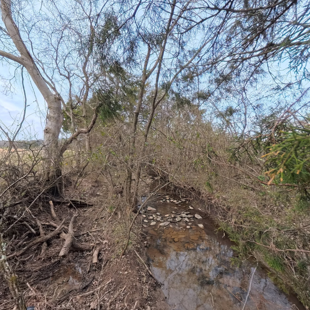
Looking downstream, a very small stream channel is visible with shallow water flowing over a limestone/flat rock substrate. The channel is narrow (approximately 3-5 feet wide) and flanked by dense dormant vegetation including cedars (eastern red cedar) and deciduous trees. Flat tabular rocks are exposed as mid-channel bars and bed substrate.
Keywords
Right Face (NE - 40°)
Summary
Looking toward the right bank (when facing downstream), dense dormant vegetation is visible including eastern red cedar trees and tangled deciduous shrubs and vines. The bank rises moderately from the channel with a mix of grass and dormant herbaceous cover. The vegetation is thick but largely bare of leaves, suggesting winter dormancy. Some cedars retain green foliage.
Keywords
Back Face (SE - 130°)
Summary
Looking upstream, the narrow stream channel stretches away with a rocky limestone bed clearly exposed. Water is very shallow, flowing in a thin ribbon over flat rock substrate. The channel is flanked by cedars and deciduous trees on both sides, with an open agricultural field visible through the trees on the right (which corresponds to the left bank when facing downstream). The rocky bed shows natural layered limestone with some larger cobble/flat rock pieces.
Keywords
Left Face (SW - 220°)
Summary
Looking toward the left bank (when facing downstream), an expansive open agricultural field (pasture/hay) is visible beyond a narrow strip of riparian trees. A red barn and farm structures are visible in the distance approximately 500+ feet from the stream. The bank itself is moderately high with exposed roots and rock. The riparian buffer on this side appears thin, with the agricultural field encroaching relatively close to the channel. A fluorescent green hard hat or safety equipment is visible at the bottom of frame, confirming backpack-pole survey method.
Keywords
Up Face
Summary
The upward view shows a canopy of eastern red cedar (Juniperus virginiana) and dormant deciduous trees. The cedars retain green needle-like foliage while the hardwoods are completely bare. The canopy provides moderate to dense cover over the channel, with light gaps visible through the bare deciduous branches. The sky is mostly clear to partly cloudy.
Keywords
Down Face
Summary
Looking down, the camera operator is visible wearing a high-visibility yellow/green hard hat and dark clothing, standing on the bank/bed of the stream. The stream bed is visible with flat limestone rocks and cobble substrate. A fallen log crosses the channel. Shallow water with a brownish tint is visible among the rocks. The bank surface shows bare soil, leaf litter, and small woody debris. The operator is holding the backpack camera pole.
Keywords
Overall Stream Score
Component Scores
Supplemental Assessments
Limiting Factors
Primary Stressors
Assessment Summary
Black Branch 24 at scene #4 is a small headwater stream in marginal condition flowing through a rural agricultural landscape near Lebanon, Tennessee. The channel retains natural limestone substrate and reasonable water quality, but is significantly impacted by a narrow riparian buffer on the left bank where pasture/hay field encroaches close to the channel. The stream shows moderate incision, limited pool habitat, and reduced depth diversity that constrains aquatic life potential. Priority management actions should focus on riparian buffer restoration on the left bank and improved agricultural runoff management to maintain and enhance this headwater stream's ecological function.
Comparison to Reference
Deviation: Moderate
For a headwater limestone stream in the Nashville Basin of Middle Tennessee, this reach shows moderate deviation from reference condition. The natural substrate is intact and water quality appears acceptable, but the riparian buffer has been severely reduced on the left bank by agricultural land use. A reference condition stream of this type would have wider forested buffers on both banks, better floodplain connectivity, greater pool depth and habitat diversity, and more robust macroinvertebrate habitat. The cedar-dominated riparian corridor suggests past disturbance and possible succession from cleared land.
Management Recommendations
MS4 Compliance Actions
Permit Req: visual_stream_survey
Timeline: annual
Permit Req: dry_weather_screening
Timeline: annual
Stream Restoration Recommendations
BMP Recommendations
Priority Locations: Left bank riparian zone where agricultural field abuts the stream with minimal buffer. This is the highest priority for restoration. Filter strips or vegetated buffers along the left bank would significantly reduce sediment and nutrient loading.
Monitoring Recommendations
Referrals Needed
Public Communication
Management Notes
This reach of Black Branch 24 represents a common condition in Middle Tennessee agricultural headwater streams where riparian buffers have been reduced by farming. The stream retains natural substrate and reasonable baseflow water quality, making it a good candidate for restoration through buffer enhancement. Coordination with the adjacent landowner(s) would be essential. The presence of eastern red cedar in the existing buffer suggests early successional recovery that could be augmented with diverse native tree plantings. The limestone bed substrate provides a stable foundation that should support improved habitat if pools can be enhanced through woody debris additions. This is scene #4 of 53 so conditions along the reach should be compared with downstream observations for comprehensive management planning.
Channel Assessment
Stream Characteristics
TDEC Stream Classification
Small headwater stream flowing through agricultural corridor with narrow riparian buffer. Stream appears to support baseflow and basic aquatic habitat but is limited by narrow channel, low flow, and adjacent agricultural land use. No obvious impairment indicators at this location.
Channel Condition Scores
The channel appears largely natural with no direct structural modifications. However, the moderate incision (banks are 3-6 ft on the left side) and disconnection from the floodplain suggest some degree of downcutting, likely related to land use changes in the watershed. The channel geometry appears relatively stable at present with natural bed substrate intact.
The channel shows moderate incision, particularly evident on the left bank where banks are 3-6 ft high and steep. Adjacent agricultural land use suggests altered hydrology from drainage modifications. The low flow condition with significant exposed substrate suggests the channel may be oversized relative to current baseflow, indicating flashy hydrology typical of agricultural watersheds.
Some sediment deposition is evident as gravel and flat rock accumulation in the mid-channel area visible in the front view. The substrate appears to be a mix of bedrock-influenced limestone pieces and transported gravel. Approximately 10-25% of the visible bed shows signs of active deposition. Pools appear limited, suggesting some infilling.
At current low flow conditions, the stream is dominated by very shallow runs and riffles. No deep pools or deep fast sections are visible. The entire visible reach appears to be shallow (under 6 inches). Only slow-shallow and fast-shallow regimes appear present.
Water is present but occupies only about 25-50% of the channel width. Significant amounts of substrate are exposed, particularly the flat limestone rocks in the front view where water barely covers much of the bed. The channel appears oversized relative to current baseflow.
The visible reach shows some variation between shallow runs and what appear to be riffle-like features over the rocky substrate, but the low flow makes definitive riffle identification difficult. The channel appears to have some natural riffle-pool sequences based on substrate variation, scoring moderate.
Geomorphic Classification (Rosgen)
This small headwater stream in the Nashville Basin shows characteristics of a low-gradient stream on limestone substrate. The moderate entrenchment and relatively wide-shallow geometry suggest it may be transitioning between E and F type. The channel appears to have experienced some incision, likely related to agricultural land use changes, creating steeper banks than expected for the natural condition. The limestone bedrock influence helps maintain bed stability. Classification confidence is low due to limited view of the overall planform and difficulty assessing bankfull indicators from a single panoramic point.
Bank Assessment
Left Bank
No structural bank modifications observed on left bank.
The left bank (visible in the left face view and partially from back) shows moderate to steep banks approximately 3-6 ft high. There is moderate root exposure and some bare soil, indicating active erosion processes. The bank appears moderately stable with some tree and shrub root stabilization, but the steep angle and exposed soil suggest vulnerability to further erosion during high flows.
The left bank shows approximately 50-65% vegetative coverage. The riparian buffer is thin on this side, transitioning quickly to open agricultural field. Bare soil patches are visible, and some areas show root exposure. Some cedar and deciduous trees provide bank protection but coverage is incomplete. The narrow buffer and proximity of agriculture reduce vegetative protection effectiveness.
Left bank is steeper and more eroded than right bank. The narrow riparian buffer transitions rapidly to open agricultural pasture/hay field. Root exposure is moderate indicating active bank erosion. Red barn and farm structures visible approximately 500+ ft from stream.
Right Bank
No structural modifications observed on right bank.
The right bank appears more stable than the left, with lower bank heights in many areas and denser vegetation coverage. The dense cedar and shrub growth provides root stabilization. Erosion is minimal from this vantage point. Bank heights are moderate but vegetation is providing adequate protection.
The right bank shows approximately 75-85% vegetation coverage with dense cedar trees, shrubs, and understory growth. The vegetation appears largely native with eastern red cedar dominant. Minor patches of bare soil exist but the bank is generally well-protected. The riparian zone appears wider on this side.
Right bank is more stable than left, with denser vegetation and lower bank heights in places. Cedar trees provide good root stabilization. The riparian buffer appears wider on this side, contributing to better bank stability.
Riparian Assessment
Left Riparian
The left riparian buffer is very narrow, estimated at approximately 10-25 feet before transitioning to open agricultural pasture/hay field. For a stream approximately 5 feet wide, this represents roughly 2-5x the channel width, but the absolute width is narrow and the buffer is thin with sparse understory. The filtering function for agricultural runoff is compromised by the narrow width.
Right Riparian
The right riparian zone appears wider than the left, estimated at approximately 25-50 feet of dense cedar and mixed vegetation. This provides moderate filtering and habitat functions. The buffer appears more continuous than the left side.
Floodplain Vegetation
The floodplain vegetation is marginal. On the left side, the floodplain has been converted to agricultural pasture/hay field with minimal natural vegetation. The right side has a cedar-dominated strip but the floodplain beyond is likely also agricultural. The overall floodplain vegetation is not in a natural state, dominated by agriculture with a narrow strip of trees along the channel.
Canopy Cover
Currently in winter with bare deciduous trees, the canopy provides moderate shade. In summer with full leaf-out, the combination of evergreen cedars and deciduous trees would likely provide 50-75% shade. The narrow buffer on the left side allows more light penetration. For a warmwater stream, this represents a reasonable shade level providing a mix of conditions.
TDEC Buffer Compliance
The left bank riparian buffer is inadequate, with agricultural pasture/hay field encroaching close to the channel. Buffer restoration on the left side through tree planting and exclusion fencing would significantly improve filtering capacity and bank stability. The right side buffer is marginal but more adequate.
Instream Habitat & Biological Indicators
Approximately 25-35% of the visible substrate is favorable for colonization. Some cobble/flat limestone provides attachment surfaces, a few fallen logs are present, and minor undercut banks exist. However, the shallow flow depth limits the utility of much of the substrate, and the overall habitat diversity is limited. The channel lacks large boulders and abundant woody debris that would provide more complex habitat.
The limestone cobble and gravel substrate shows moderate embeddedness with approximately 25-40% of the rocks surrounded by fine sediment. The flat tabular rocks are partially embedded in sand and silt, particularly in the lower-velocity areas. Some areas show clean exposed rock while others have notable fine sediment accumulation.
Pools are nearly absent in the visible reach. The entire stream bed is visible/discernible due to the very shallow depth. Any pools that exist are extremely shallow (under 6 inches). The low flow conditions and narrow channel severely limit pool development.
Only 3 fish cover types are identifiable: some fallen logs/woody debris, minor undercut banks, and overhanging vegetation (especially the low cedar branches). Deep pools, boulder cover, macrophyte beds, and backwater pools are absent. The shallow depth severely limits fish habitat suitability.
No physical barriers are visible in this reach. However, the very low flow conditions could seasonally inhibit fish movement through this section. The shallow depth may be a functional barrier during low flow periods.
Several pieces of LWD are visible, including at least one log spanning the channel visible in the down view and scattered smaller pieces. Estimated 4-6 pieces per 100m visible reach. No significant debris jams are present. The pieces are mostly small to medium sized. One log crosses the channel but does not appear to be forming pools due to the low flow and shallow depth.
Biological Indicators
Four habitat types are present: coarse gravel/cobble substrate, a few submerged logs, accumulated leaf packs from winter leaf fall, and minor undercut banks. However, the very shallow depth and low flow limit the quality and availability of these habitats. The cobble substrate shows moderate embeddedness. Scoring between 3-4 due to moderate habitat count but limited quality.
Habitat assessment suggests potential for a moderate macroinvertebrate community. The limestone cobble substrate provides some colonization surfaces, and leaf packs offer food resources. Score of 6 reflects assumed facultative community based on habitat conditions, as direct observation from imagery is not possible.
No macroinvertebrates were directly observed from the imagery. Score assigned based on habitat assessment rather than direct observation. The substrate diversity and presence of some woody debris suggest potential for Group II (facultative) organisms. Winter conditions and low flow may reduce visible macroinvertebrate activity.
Wildlife Observations
Suitable Habitat: No
The small, shallow stream with limited pool habitat is unlikely to support sensitive aquatic species. The agricultural setting and narrow buffer reduce habitat quality for most species of concern. The cedar corridor provides some shelter for terrestrial wildlife but the habitat is limited.
No wildlife directly observed in imagery. Winter conditions and the presence of the survey crew likely reduced wildlife visibility. The dense cedar/shrub cover could provide shelter for small mammals and birds. Brush piles visible in multiple faces could serve as wildlife cover.
Water Quality Indicators
Water has a slightly brownish/tea coloration but the bed is clearly visible through the shallow depth. Clarity appears moderate - not heavily turbid but not crystal clear either. The brown tint could be from natural tannins or minor sediment. No sheen, foam, or unusual coloration noted. The shallow depth makes clarity assessment somewhat limited.
No significant algal growth or macrophyte density is visible. The water does not appear green. Winter conditions may limit algal growth but no obvious nutrient enrichment indicators are present. The adjacent agricultural field could contribute nutrients during runoff events, but baseflow conditions show minimal enrichment evidence.
No direct evidence of manure or waste is visible in the stream or on banks. However, the adjacent agricultural field (visible in left view) with red barn/farm structures in the distance suggests potential livestock operations nearby. No obvious livestock access to the stream is visible at this point, but the narrow buffer raises concern about potential manure transport during storm events.
Surface Contamination
Thermal Indicators
This appears to be a warmwater stream with moderate winter shade from cedar trees and bare deciduous trees. Summer shade would increase with leaf-out but the thin left-bank buffer would still allow solar exposure. The agricultural setting with minimal impervious surface means thermal impacts from stormwater are unlikely. The shallow depth makes this stream vulnerable to temperature extremes in summer. Expanding the left-bank riparian buffer would improve shade and thermal conditions.
Stormwater Infrastructure
Outfall Inventory
Dry Weather Screening
Outfall Area Condition
Upstream Drainage Area
Environment & Conditions
Observation Conditions
Floodplain Characteristics
Utility Crossings Inventory
No utility crossings or associated infrastructure visible at this location.
Recent Disturbance Assessment
No recent disturbance visible at this location. The area appears stable with no evidence of recent construction, clearing, or modification activity.
No apparent permit violations or compliance concerns at this specific location. The narrow riparian buffer on the left bank is a long-term land use issue rather than a recent disturbance.
Invasive Species Inventory
Terrestrial Invasives Assessment
Aquatic Invasives Assessment
No aquatic invasives detectedSpecies assessed (6 not present)
Some vine growth on trees and shrubs that could be Japanese honeysuckle (Lonicera japonica) is tentatively identified in the winter dormant condition, but confidence is low. The dense tangle of vines visible in several faces may include invasive honeysuckle. Eastern red cedar (Juniperus virginiana) is native to the region but its dominance in the riparian corridor may indicate past disturbance. A more thorough growing-season survey would be needed for confident invasive species identification.
Front Face (NW - 310°)
Looking downstream, a very small stream channel is visible with shallow water flowing over a limestone/flat rock substrate. The channel is narrow (approximately 3-5 feet wide) and flanked by dense dormant vegetation including cedars (eastern red cedar) and deciduous trees. Flat tabular rocks are exposed as mid-channel bars and bed substrate.
Water Features
Channel Features
Bank Features
Vegetation
Debris & Trash
Right Face (NE - 40°)
Looking toward the right bank (when facing downstream), dense dormant vegetation is visible including eastern red cedar trees and tangled deciduous shrubs and vines. The bank rises moderately from the channel with a mix of grass and dormant herbaceous cover. The vegetation is thick but largely bare of leaves, suggesting winter dormancy. Some cedars retain green foliage.
Channel Features
Bank Features
Vegetation
Debris & Trash
Back Face (SE - 130°)
Looking upstream, the narrow stream channel stretches away with a rocky limestone bed clearly exposed. Water is very shallow, flowing in a thin ribbon over flat rock substrate. The channel is flanked by cedars and deciduous trees on both sides, with an open agricultural field visible through the trees on the right (which corresponds to the left bank when facing downstream). The rocky bed shows natural layered limestone with some larger cobble/flat rock pieces.
Water Features
Channel Features
Bank Features
Vegetation
Debris & Trash
Left Face (SW - 220°)
Looking toward the left bank (when facing downstream), an expansive open agricultural field (pasture/hay) is visible beyond a narrow strip of riparian trees. A red barn and farm structures are visible in the distance approximately 500+ feet from the stream. The bank itself is moderately high with exposed roots and rock. The riparian buffer on this side appears thin, with the agricultural field encroaching relatively close to the channel. A fluorescent green hard hat or safety equipment is visible at the bottom of frame, confirming backpack-pole survey method.
Channel Features
Bank Features
Vegetation
Debris & Trash
Up Face
The upward view shows a canopy of eastern red cedar (Juniperus virginiana) and dormant deciduous trees. The cedars retain green needle-like foliage while the hardwoods are completely bare. The canopy provides moderate to dense cover over the channel, with light gaps visible through the bare deciduous branches. The sky is mostly clear to partly cloudy.
Channel Features
Vegetation
Down Face
Looking down, the camera operator is visible wearing a high-visibility yellow/green hard hat and dark clothing, standing on the bank/bed of the stream. The stream bed is visible with flat limestone rocks and cobble substrate. A fallen log crosses the channel. Shallow water with a brownish tint is visible among the rocks. The bank surface shows bare soil, leaf litter, and small woody debris. The operator is holding the backpack camera pole.